| Every year NWO awards research grants to talented researchers as part of the NWO Veni, Vidi, Vici scheme. With a Veni grant, highly promising young researchers can further elaborate their own ideas during a period of three year. Last week one of these Veni grants was awarded to Obbe Tuinenburg for his proposal to improve drought predictability. |  |
|
0 Comments
 by Brian Dermody
The European Geosciences Union conference takes place every year in Vienna. It hosts around 15,000 scientists on all topics to do with geoscience. This year I was invited to take part in one of the daily press conferences they organise. The topic of the press conference was Past civilisational resilience and collapse.  As environmental scientist I’m confronted with the effects humans have on the environment every day. At a given moment I read about the effects of livestock and agriculture. I began to delve in and got shocked. In various scientific literature you can find that the consumption of animals products cause 18% of global greenhouse gases, a large part of deforestation (70% in the Amazon), desertification, rapidly declining fish stocks, water scarcity, increasing risk of resistant diseases through antibiotics, terrestrial and aquatic nitrogen pollution, loss of biodiversity, animal cruelty, et cetera. In addition to these environmental problems I read that humans can live perfectly well without eating any animal products. There is even evidence that high intake of animal product cause several health problems known particularly in the west. And then I asked myself: why I should be part of this damaging system if I can have a perfectly happy life with a plant based diet?
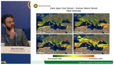
by Kees Klein Goldewijk. There are conferences and conferences, but the yearly Fall Meeting of the American Geophysical Union (short: AGU) in December in San Francisco is by far one of the largest conferences around. I wrote this blog amongst my fellow participants, all 25.000 (!) of them, and it feels sometimes really like being in an ant-hill, with so many people running, walking, hanging out, or desperately searching for the right session or location everywhere.  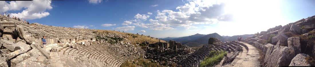 The theatre at Sagalassos Stefan Dekker and I recently attended a workshop at the ancient city of Sagalassos located high in the mountains in south-west Turkey. The idea of the meeting was to bring together researchers from a range of disciplines to understand the history of Sagalassos in the context of a complex socio-ecological system integrated within the wider Roman world. Studies of ancient societies can be extremely informative in a sustainability context as they can illustrate the long-term implications of short-term socio-ecological interactions.
 Blog entry by David Bijl - PhD student
Water scarcity has been on the international agenda for a few years now (OECD, 2012; UNEP, 2012). Overuse of freshwater resources has already caused environmental degradation in many locations, and causes significant economic and health risks as well. However, the problem can get much worse in the future, with continued population growth and economic development. That’s why researchers like me build computer models: to get a better idea of how water demand and availability may change in the future. In 2013 I started my PhD on the hydrogeochemistry of the Sand Motor. While talking to my friends about this, it wasn’t until 2014 they figured out what the Sand Motor actually was supposed to be. This was probably because of the ‘science communication’ you get into when you spend too much time at university. My friends imagined the Sand Motor being what the name describes: a HUGE electric motor in the sea that replenishes the beaches and dunes with sand. Unclear was the practical part, for example, the kind of volumes or where the sand came from, but they were right about the Sand Motor being a kind of motor, but without all the electric stuff.. A bit of a disappointment for my friends, but the Sand motor is nothing more than a massive pile of sand located at Kijkduin, south of Scheveningen. It was put there by the dredging companies Boskales and Van Oord in 2011 and initially looked like an island shaped as a hook. Because of its precise shape it started off being a huge art piece and with its 2 km stretch and 1 km width the Sand Motor was as big as 256 soccer fields. During its first year, the shape of the Sand Motor changed rapidly. Wind, waves and currents started to transport the sand to the north and south of the Sand Motor, but also towards the dunes and even back into the sea. Because of the rapid changes we all thought the model predictions were wrong and the Sand Motor would soon disappear. However, the Sand Motor just needed to change from an art structure into a natural formed peninsula and soon after the Sand Motor started to change as planned. 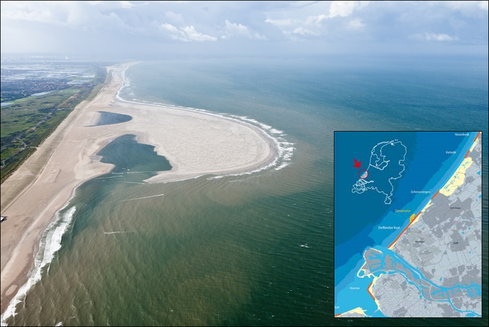 The location of the Sand Motor and its shape in september 2011
My name is Kees Klein Goldewijk and I’ve joined Copernicus as a research fellow last year on a VENI grant from NWO. The topic of my grant is: "Looking back to the future: improving historical land use reconstructions for better understanding of the global carbon cycle". The main research questions are: When did human activities trigger global environmental change at relevant scales? And how did these activities such as settlement strategies and agriculture affect land use and land cover, the global carbon cycle and climate? I’d like to explain in my blog about my project and all the highly interesting problems (and solutions!) I do encounter. Follow me on a epic journey into the past... 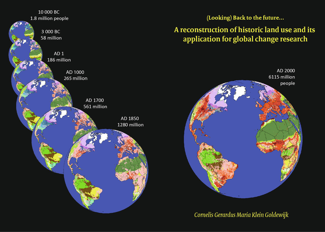  Blog entry by Floris Keizer - Junior Lecturer / Researcher In our project, we look at sediment transport and deposition in a lowland river and on the adjacent floodplain, which means most of the work happens during and after flood events in winter and spring. On this, I have written several blog posts (Ecohydrology and MSc work in 2012; Ecosystem services of sedimentation; Unexpected early flooding in January and a second flood peak in April). However, what is the use of characterizing sediment and attached nutrient input is you have nothing to relate it too? During dry phases, the imported nutrients are made available for plant growth. This was the topic of my summer field campaign beginning of August and hence the rationale behind the title as now I completed the Four Seasons of Olszowa Droga, one of my sampling locations. 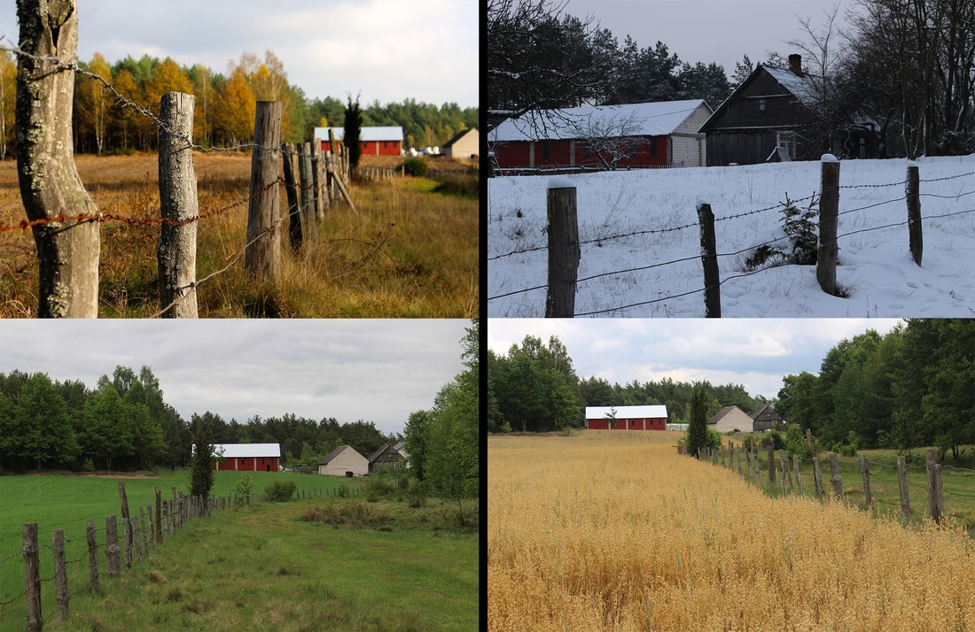 Autumn, winter, spring and summer in Olszowa Droga (Alder Road). With vegetation productivity (measured as aboveground biomass of living vascular plants) and plant species recordings at every site where sediment transport and deposition was measured, we can now hopefully say something about the actual effect of sediment on vegetation productivity and plant species diversity.
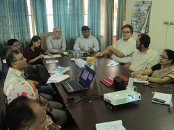 Meeting with local NGO in Khulna, Jagrata Juba Shangha (JJS) Meeting with local NGO in Khulna, Jagrata Juba Shangha (JJS) Background on the Living Polders Research Project
Bangladesh is home to one of the biggest and most densely populated deltas of the world, formed by sediments carried by the Ganges, Brahmaputra and Meghna River system. The construction of polders in the 1960s in order to decrease flood risk and salinity intrusion, resulted in high agricultural productivity on the coastal lands for 10-15 years. However since the 1980s, the polders have become a source of major environmental concern due to salinisation, land subsidence, and water logging problems caused by sedimentation in the channel beds. Within this context, the Living Polders research project aims to develop sustainable solutions to these increasing pressures through integrated polder management, based on building with nature principles, working with rather than against the forces of nature (e.g. temporarily opening up polders to benefit from natural sediment accretion to elevate polder surfaces, and deposit fertile nutrients), and taking into account the natural and social dynamics in the area. Utrecht University has ample experience with studying building with nature techniques based on sediment management (see for example the blog contributions by Floris Keizer on suspended sediment, by Rémon Saaltink on the Marker Wadden project, and the work by Hans Middelkoop and others on the River Care project as well as Jasper Griffioen’s involvement in the Sand Motor project). As part of the final step for the development of the Living Polders research proposal under the NWO Programme "Urbanizing Deltas of the World", our team of researchers travelled to Bangladesh: Dr Frank van Laerhoven, Dr Jasper Griffioen, Dr Michiel van der Meulen, and Ariane Laporte-Bisquit. The objective of this trip was to consult with various local stakeholders and have a better understanding of the reality on the ground. The next paragraphs describe some of the key highlights of this succesful trip. |
Archives
March 2018
Categories
All
Environmental Sciences BlogWritten by the junior researchers, PhD-students and post-docs of the Environmental Sciences group. |
 RSS Feed
