by Brian Dermody
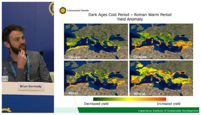
The European Geosciences Union conference takes place every year in Vienna. It hosts around 15,000 scientists on all topics to do with geoscience. This year I was invited to take part in one of the daily press conferences they organise. The topic of the press conference was Past civilisational resilience and collapse.
The European Geosciences Union conference takes place every year in Vienna. It hosts around 15,000 scientists on all topics to do with geoscience. This year I was invited to take part in one of the daily press conferences they organise. The topic of the press conference was Past civilisational resilience and collapse.

 RSS Feed
