Blog entry by Rémon Saaltink - PhD student
If Cornelis Lely could know that lake Markermeer is still a lake, he'd be turning in his grave! Land reclamation from this lake should have taken place long ago. However, the Dutch government decided to cancel these plans recently after decades of dispute. Having an extra, large fresh water lake is all very well but the current ecological value of the lake is rather poor. Primary productivity in the lake is low as light penetration is reduced due to suspended particles in the water column. Additionally, a fluffy layer at the lakes bed provide poor conditions for (aquatic) plants and other animals such as fish and benthic fauna. You can easily say that Markermeer currently functions as a big aquatic desert. So how did this come about? To answer that, lets first dive briefly into history!
If Cornelis Lely could know that lake Markermeer is still a lake, he'd be turning in his grave! Land reclamation from this lake should have taken place long ago. However, the Dutch government decided to cancel these plans recently after decades of dispute. Having an extra, large fresh water lake is all very well but the current ecological value of the lake is rather poor. Primary productivity in the lake is low as light penetration is reduced due to suspended particles in the water column. Additionally, a fluffy layer at the lakes bed provide poor conditions for (aquatic) plants and other animals such as fish and benthic fauna. You can easily say that Markermeer currently functions as a big aquatic desert. So how did this come about? To answer that, lets first dive briefly into history!
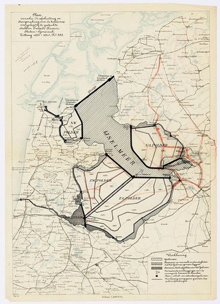 Figure 1. Plan Lely, 1891.
 Already in 1667, a guy called Hendrik Stevin proposed a plan to seal off the Southern Sea (Zuiderzee) from the Wadden Sea to prevent damage from frequently occurring floods in the area. Unfortunately, it was impossible to build dams and dikes on such a large scale at that time. It took well over 200 years to come up with a new plan! In 1891, Cornelis Lely proposed to close off the Southern Sea from the Wadden Sea to create four separate polders (Figure 1). The first phase, the closure of the Southern Sea, was realized in 1932 by the construction of the Enclosure Dam (Dutch: Afsluitdijk). Nowadays, three polders have been realized (Figure 2). One polder belongs to the North-Holland province while the remaining two formed a new province, founded in 1986: Flevoland. The fourth polder has never been realized although the first preparations were already made: The Houtrib Dam was finalized in 1976 and separates the IJsselmeer from Markermeer. The original idea was to create the fourth polder from Markermeer, turning it into the “Markerwaard”. After decades of discussions and debates, the Dutch government finally decided in 2006 to cancel plans of land reclamation in this lake.
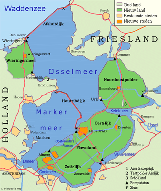 Figure 2. Current situation.
 Nowadays, a thick, fluffy layer of silt dominates the lakes bed. Markermeer is relatively shallow with an average depth of 3.6 meters. Already at low wind speeds, the wind-induced waves cause erosion and resuspension of the fluffy layer. In turn, this results in a high concentration of suspended particles which prevents light to penetrate deep into the water column. This fluffy layer originates from the underlying Southern Sea deposit. This deposit is eroding at very high wind speeds and due to bioturbation by worms like Tubifex. This eroded material cannot be transported away to the IJsselmeer because of the Houtrib Dam so eventually, the eroded material settles down on top of the Southern Sea deposit forming this fluffy layer. It is this fluffy layer that is the cause of the current deterioration of the ecosystem in the lake.
To improve the ecological value of the lake, the Dutch society for preservation of nature monuments (Natuurmonumenten) proposed to create artificial island along the Houtrib Dam: Marker Wadden. In this plan, the thick, fluffy layer of silt is used as building material for the islands thereby improving the ecological conditions in the lake as the fluffy layer is removed. In addition, wetlands are created on a large scale by island formation. Hence, Marker Wadden will kill two birds with one stone! The islands will consist of shell reefs, sandbars, swamps and reed beds which will be accompanied by a rich flora and fauna. For an impression, see the (Dutch) video at the end of this post.
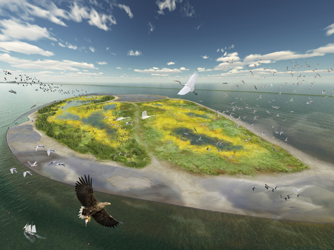
Figure 3. An artist's impression of the Marker Wadden.
A few months ago, I started my PhD project where I will investigate how aquatic and wetland ecological processes will feedback and interact with the consolidation and soil forming processes on these islands. The challenge in this project is to understand the interplay and feedbacks between biogeochemistry, hydrology, sedimentology, geomechanics and aquatic and terrestrial ecology. I’ll hope to blog regularly about my research activities! The first experiments are already scheduled this summer. Stay tuned for more posts!
 RSS Feed
