My name is Kees Klein Goldewijk and I’ve joined Copernicus as a research fellow last year on a VENI grant from NWO. The topic of my grant is: "Looking back to the future: improving historical land use reconstructions for better understanding of the global carbon cycle". The main research questions are: When did human activities trigger global environmental change at relevant scales? And how did these activities such as settlement strategies and agriculture affect land use and land cover, the global carbon cycle and climate? I’d like to explain in my blog about my project and all the highly interesting problems (and solutions!) I do encounter. Follow me on a epic journey into the past...
But first, let’s go where it all began. I started working in the early 90s at the PBL Netherlands Environmental Assessment Agency in Bilthoven. PBL is the Dutch national institute for strategic policy analysis in the field of environment, nature and spatial planning. Its core task is to investigate and document current and future environmental, ecological and spatial quality, and evaluate possible policy options. An important tool that PBL uses is IMAGE, an Integrated Model to Assess the Global Environment. IMAGE is an ecological-environmental model framework that simulates the environmental consequences of human activities worldwide. It represents interactions between society, the biosphere and the climate system to assess sustainability issues such as climate change, biodiversity and human well-being. The objective of the IMAGE model (version 3.0, released in 2014) is to explore the long-term dynamics and impacts of global changes that result from interacting demographic, technological, economic, social, cultural and political factors (see www.pbl.nl/image).
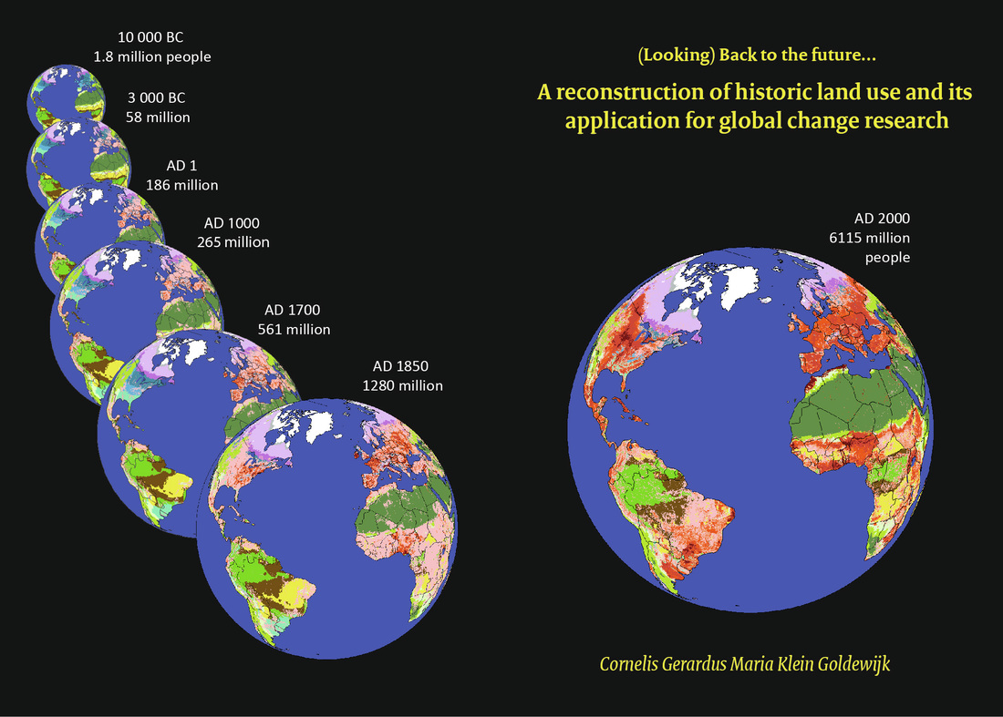
International reviews of the IMAGE framework lead in the late 90s to a need for historical validation and calibration of IMAGE (“if you model the next hundred years, your model should at least be able to reproduce the past hundred years, to be credible”), so I started collecting all the historical data needed for this daunting task. Since no spatially referenced maps of global historical population and land use existed in those days, I decided to create them myself, and voila: the HYDE database was born.
Tool: HYDE, what is it?
HYDE stands for History Database of the Global Environment (www.pbl.nl/hyde) and started as a data base of many historical indicators. The first version was on a regional basis and for the past hundred years. Over time, HYDE became spatially explicit en the time period covered was extended. The current HYDE version 3.1 is an updated and internally consistent combination of historical population estimates and also an implementation of improved allocation algorithms with time-dependent weighting maps for population, built-up area, cropland and land used for grazing, all on a 5 arc-minute resolution, while the period covered is extended to 10,000 BC to AD 2010. Continuous updating and elaboration of historical and archaeological sources is in full progress. Version 3.2 will also include irrigated areas, rice and managed/unmanaged pasture (scheduled 2015), while final version 4.0 will include a full land cover classification (scheduled 2018).
For this version 4.0, we need to have a historical integrative model called HIMAGE (= Holocene IMAGE). It is an attempt to run the existing IMAGE model (from PBL) for a long historical period, roughly 12,000 years (the beginning of sedentary agriculture). It requires substantial re-coding of the original IMAGE model, a major historical data input effort and re-thinking of some existing modules of the model. Once running, internal feedbacks in the (climate) system can be researched and its consequences on the global carbon and hydrological cycle, all topics which are highly relevant for Copernicus J
What is HYDE used for?
HYDE is used in many different applications; scientific research, policy questions, for educational and teaching purposes and for general public interest. A few examples are given here.
Global Carbon Project
The Global Carbon Project (GCP) was established in 2001 in recognition of the large scientific challenges and critical nature of the carbon cycle for Earth's sustainability. The scientific goal of the project is to develop a complete picture of the global carbon cycle, including both its biophysical and human dimensions together with the interactions and feedbacks between them. HYDE provides yearly updates on the land use part (http://www.globalcarbonproject.org/)
CMIP5,6 / LUMIP | Land Use Model Inter-comparison Project
Human land-use activities have resulted in large changes to the biogeochemical and biophysical properties of the Earth surface, with resulting implications for climate. In the future, land-use activities are likely to expand and/or intensify further to meet growing demands for food, fiber, and energy. The Fifth Coupled Model Inter-comparison Project (CMIP5, http://cmip-pcmdi.llnl.gov/) achieved a qualitative scientific advance in studying the effects of land-use on climate, for the first time explicitly accounting for the effects of global gridded land-use changes (past-future) in coupled carbon-climate model projections. Enabling this advance, the first consistent gridded land-use dataset (past-future) was developed, with HYDE as the only historical land use input, linking historical land-use data, to future projections from Integrated Assessment Models, in a standard format required by climate models. Results indicate that the effects of land-use on climate, while uncertain, are sufficiently large and complex to warrant an expanded activity focused on land-use for CMIP6 (http://www.wcrp-climate.org/wgcm-cmip/wgcm-cmip6 and http://luh.umd.edu/).
A virtual water network of the Roman world
Together with UU colleague’s, PBL, Wageningen University (WUR) and Stanford University (USA) we’ve developed a virtual water network for the Mediterranean for 200 AD, where we looked into irrigation and virtual water trade which increased Roman resilience to climate variability in the short term. However, urbanization arising from virtual water trade likely pushed the Empire closer to the boundary of its water resources, led to an increase in import costs, and reduced its resilience to climate variability in the long-term. HYDE is used as input for agricultural and population patterns in those days and at this moment we are updating and improving the whole model setup (http://www.hydrol-earth-syst-sci.net/18/5025/2014/hess-18-5025-2014.html)
PAGES LandCover6K working group
The PAGES (Past Global Changes) project is an international effort to coordinate and promote past global change research, and is funded by the US and Swiss National Science Foundations and NOAA, is a scientific partner of WCRP, and a core project of IGBP with plans to transition into Future Earth over the next year (see http://www.pages-igbp.org/).
Adequate incorporation of land cover in global and regional climate models is still one of the major priorities in the climate modelling community. In particular, anthropogenic land cover change (ALCC) is still not successfully implemented in these models. As a result, climate modelling in paleo-mode or projection mode that tries to take ALCC into account is seriously hampered (Strandberg et al., 2014). The question of whether humans had more impact on climate in prehistory (from 3k BP or earlier) than previously assumed, is still a matter of debate. Thus, the effect of anthropogenic burning and deforestation on global climate via biogeochemical and bio-geophysical processes in the past is not fully understood yet, and mitigation strategies using e.g. tree plantations to create CO2 sinks and climate cooling might be erroneous. Improved descriptions of past anthropogenic land cover change at the global spatial scale are therefore needed. LandCover6k addresses land-cover change across the globe that is climate-induced, natural, AND human-induced due to anthropogenic land use from ca. 1-2 millennia before the start of agriculture. The planned products of LandCover6k are: A. Largely improved HYDE and KK models for the Holocene using land-use and land-cover reconstructions from paleo-ecological data and historical/archaeological data using products B. Land-cover and land-use maps for time windows and/or periods of the Holocene.
IMAGE 3.0
IMAGE is an ecological-environmental framework that simulates the environmental consequences of human activities worldwide. It represents interactions between society, the biosphere and the climate system to assess sustainability issues like climate change, biodiversity and human well-being. The objective of the version of IMAGE 3.0 (update of version 2.4 released in 2006) is to explore the long-term dynamics of global change as the result of interacting demographic, technological, economic, social, cultural and political factors. New features of IMAGE 3.0 will be (amongst other parts) land use modeling on a 5 arcminute resolution, a new LPJml dynamic vegetation module, and a new Forest Management Module (www.pbl.nl/image). HYDE feeds directly into the IMAGE model with historical land use and built-up area.
In the next blogs I will write about the many obstacles you can ran into when trying to find, get and incorporate all that fascinating historical/archaeological/paleo-ecological/geographical or any other relevant data that is out there, and believe me, there is a lot!
 RSS Feed
